 Back
to Business & Industry
Back
to Business & Industry|
Coal Mining in Audrain County The Coal Deposits of Missouri, 1912 |
|
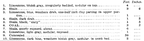
AVERAGE ANNUAL PRODUCTION, 1901-1910 ..........38,736 TONS. Nearly all of Audrain county is underlain by a thin veneer of Pennsylvanian Coal. Measures bearing beds of coal less than three feet in thickness. The central portion of the region is a level plain forming the divide between the Mississippi and Missouri river drainages, and covered so effectually by 50 feet and more of drift as to conceal the coal-bearing rocks in all but the larger valleys. Structurally the eastern half of the county is simple, the rocks lying nearly fiat when the territory is considered as a whole, though minor undulations have local effect and strata at Rush Hill and Laddonia are at higher altitudes than in the region farther east and south. The structure in the western half of the county is more complicated, because of the presence of several anticlines with axes probably trending northwest and south- east parallel to the Browns station anticline of Boone county. Out- crops are rare in this region and wells are so shallow as to yield little information concerning the stratigraphy. All of these factors, combined with the absence of strongly individualized beds where exposures do occur, make the work of the geologist very difficult. Aside from a few scattered country mines operated for local trade, mining is confined to the eastern part of the county, and shipping mines to Vandalia, Farber and Martinsburg. Nearly all of the territory east of Mexico and extending into Ralls and Montgomery counties is underlain by a remarkably persistent and uniform bed of coal about 30 inches thick and characterized by a very thin pyrite band in its lower part. The value of this bed is greatly impaired by small "slips" and by rolls in the floor and roof, though in places it is of excellent quality and can be easily worked on the longwall plan of mining; the only system in vogue in any of the mines of the county. The coal seam is correlated with the Mulky on the basis of observations made in tracing beds in Monroe county on the north and Callaway on the south, though it is possible that this conclusion is erroneous. Twenty feet higher is another coal bed that is very irregular and is eroded away in the northern part of the field. Near Mexico and on Davis fork and its tributaries are thin coal beds that are not utilized and do not justify development on any but a very small scale. Their exact stratigraphic position was not definitely determined, though it is known that they lie not far from the base of the Pennsylvanian. East and north of Centralia is a thirty-inch coal bed of excellent quality and easily mined. This district deserves more attention from mining men than it has received, both for this bed and for others that may underlie it. The surface coal is probably the Summit, though it also resembles the Mulky and to a slight extent the Tebo. The finding near Thompson of a coal bed apparently corresponding stratigraphically to the Bevier is mentioned in the following pages. The drilling which revealed this thick bed was made for water, not for coal; but the re- port of the strata penetrated corresponds so closely to the stratigraphic section southwest of Centralia that it deserves attention. So far as depth from the surface is concerned, the base of the Coal Measures is in about the same position at Mexico (110 feet), Farber (120 feet) and Vandalia (95 feet). At Martinsburg it is 165 feet, on the C. F. Clark farm, two miles north of Thompson, 100 feet, and on the J. W. Smith farm, 3 1/2, miles southeast of Mexico, 140 feet, from the surface. In all parts of the county the lowest Pennsylvanian bed is a light-colored fire clay from 10 to 40 feet thick. The total original coal supply of Audrain county, excluding beds or parts of beds less than 14 inches thick, may be roughly estimated at 1,220,000,000 tons. Of this amount approximately 1,030,000 tons have been mined since 1879, and about 50,000 in earlier years, a total of less than one-tenth of one per cent of the original content. DETAILED MENTION Vandalia.-Both coal and fire clay have been mined at Vandalia for many years, and three shafts are now developing the Mulky bed. These are (1) Standard Coal Co., hoisting 73 feet by horse-gin in the northwest corner of town, (2) Mississippi Glass Co. with a 70-foot shaft and steam power plant on the west edge of town, and (3) Audrain Coal Co. with steam hoisting equipment and shaft 82 feet deep two miles southwest of town (S. W. 1/4 S. E. 1/4 Sec. 12, T. 52 N., R. 6 W.). The Mississippi Glass Co. and the Audrain Coal Co. ship over the Chicago and Alton railroad, on which they are located, although the company first named consumes most of its product at its own brick plant. At the shaft of this company fire clay lying below the coal is mined by the room and pillar method, the coal being removed by the longwall method as at all other mines in the county. The Mulky coal is bright and of medium hardness. It contains abundant gypsum and calcite films and plates in vertical joints and pyrite in thin streaks. The bed is, in part, excellent, but many of the working faces are much affected by small faults ("slips") and by rolls of clay in the bottom and of rock and shale in the top. Where " slips" occur, the amount of clay and "sulphur" in the coal is large, and the roof is not everywhere firm. Elsewhere the roof is good except for the "niggerheads" that lie in the laminated shale; they are a source of danger to the men, and also, in places, project downward so as to. cut out part of the upper bench of coal. From 5 inches to 2 1/2 feet of "draw slate" comes down with the coal and about 2 inches sticks to the coal. Mexico.-Feeble attempts have been made from time to time to mine coal at and near Mexico, though none of them were continued for a long period. The most promising bed discovered was a four-foot coal with soft shale roof, found at the bottom of a 42-foot shaft one mile east of Mexico. Little could be learned of the extent and nature of the bed. For a time a coal 4 to 16 inches thick was mined in connection with the fire clay deposits that are so extensively developed at Mexico and occupy the same stratigraphic position as at Vandalia. Small drifts have been intermittently worked on Davis (Henry's) fork both west and north of the city, but in many places the bed exposed is too variable in thickness and quality to make mining profitable. As previously stated, the stratigraphic position of this seam is doubtful. Where the railroads cross Davis fork, 1 1/2 miles west of Mexico, the following section appears:
Coal is reported to have been found below creek level when the bridge piers were sunk. The upper portion of the above section is exposed at many points up Davis fork, down stream to its junction with Beaver Dam creek and in Beaver Dam east and southeast of Mexico. The Mississippian outcrops in South fork from near Mexico to the Monroe county line. Molino.-South of Molino, near South fork (S. W. 1/4 Sec. 25, T. 52 N., R. 9 W.), a small country drift is operated and the following section is exposed at the mine:
|
|
|
|
Farber.-On the railroad at the west edge of Farber the Lawder and Peterson Coal Co. operates an old shaft 100 feet deep. The coal and associated strata are almost identical with those at Vandalia. In parts of the mine one-half or more of the face is greatly injured by 'slips" and "rolls." Electric mining machines were formerly used but have been abandoned. The product is sold locally and to the railroad. Laddonia.-At Laddonia shafts 45 feet and less in depth were sunk in 1893 and subsequent years to a 26-inch coal bed, but were abandoned because of poor roof and much water. South of Laddonia and Farber, in the valley of Cuivre creek, several small shafts are worked with gin hoists for the country trade. Three mines were in operation in 1910: (1) James Lynch (N. E. 1/4 N. W. 1/4 See. 17, T. 51 N., R. 6 W.), shaft 45 feet; (2) J. A. Smith (N. W. 1/4 N. E. 1/4 Sec. 17, T. 51 N., R. 6 W.), shaft 35 feet; and (3) H. Hammett (S. W. 1/4 S. E. 1/4 Sec. 22, T. 51 N., R. 6 W.), shaft 32 feet. Other shafts were located at other points on Cuivre creek and also on Hickory creek. The coal bed has the same characteristics as at Vandalia, and the associated strata are also the same, as shown in the Lynch shaft. Rush Hill.--Reports of drilling done at Rush Hill are rather vague, but it is stated that 30 inches of coal was found 1 1/2 miles west of town, and none half a mile east of the depot. These reports need verification. About 2 1/2 miles northwest of the town a few shallow country shafts were once worked, but are now abandoned. Seven miles northwest of Rush Hill (N. W. 1/4 S. W. 1/4 Sec. 14, T. 52 N., R. 8 W.) is the well-known Hafner mine, a shaft 35 feet deep to the Mulky coal bed in the valley of Littleby creek. Horse power is used for hoisting and the product is sold locally. "Slips" are plentiful, but less so than at Farber and Vandalia. In the hillside near the shaft six feet of gray limestone is exposed just above the level of the above section, and less than one mile down the creek Mississippian limestone outcrops not far below the level of the coal. Martinsburg.-The Martinsburg Coal Co. operates a shipping mine beside the Wabash railroad on the west side of the town; the shaft being 136 feet deep to the Mulky coal. This seam has here all the characteristics it possesses at Vandalia, although the upper bench is about two inches thicker. The "draw slate" is about one foot thick, "slips" with a throw of 18 inches or less are plentiful, and some of the "niggerheads" are two feet in length. The working face is about 650 feet south and west of the shaft. An attempt was made to work the Summit coal, which lies 20 feet above the Mulky, but it was found to be of great irregularity in the under surface of the "niggerhead" roof. The coal ranged from a thin film to a bed four feet thick and was given up as too unreliable to work. A thin streak of coal lies still higher. The mine sump pene trates 10 feet of bouldery clay lying beneath the Mulky coal. The Summit coal is worked by the W. C. Carr country mine 3 ½ miles southwest of Martinsburg (S. E. 1/4 S. W. 1/4 Sec. 28, T. 50 N., R. 7 W.) from a gin shaft 52 feet deep. The roof is black laminated shale filled with oval limestone "niggerheads." that project downward into the coal in such a manner as to make its thickness vary from 2 1/2 to 4 feet. The coal is of good quality and contains only a moderate amount of sulphur chiefly in vertical streaks of pyrite. The Summit bed has been opened by small drifts at one or two points near the head of a small branch one mile north of Carr's, but under much of the district the seam is too thin to be utilized. Martinsburg.-The Martinsburg Coal Co. operates a shipping mine beside the Wabash railroad on the west side of the town; the shaft being 136 feet deep to the Mulky coal. This seam has here all the characteristics it possesses at Vandalia, although the upper bench is about two inches thicker. The "draw slate" is about one foot thick, "slips" with a throw of 18 inches or less are plentiful, and some of the "niggerheads" are two feet in length. The working face is about 650 feet south and west of the shaft. An attempt was made to work the Summit coal, which lies 20 feet above the Mulky, but it was found to be of great irregularity in the under surface of the "niggerhead" roof. The coal ranged from a thin film to a bed four feet thick and was given up as too unreliable to work. A thin streak of coal lies still higher. The mine sump penetrates 10 feet of bouldery clay lying beneath the Mulky coal. The Summit coal is worked by the W. C. Carr country mine 3 ½ miles southwest of Martinsburg (S. E. 1/4 S. W. 1/4 Sec. 28, T. 50 N., R. 7 W.) from a gin shaft 52 feet deep. The roof is black laminated shale filled with oval limestone "niggerheads." that project downward into the coal in such a manner as to make its thickness vary from 2 1/2 to 4 feet. The coal is of good quality and contains only a moderate amount of sulphur chiefly in vertical streaks of pyrite. The Summit bed has been opened by small drifts at one or two points near the head of a small branch one mile north of Carr's, but under much of the district the seam is too thin to be utilized. A short distance below the coal is a band of light gray limestone, one foot thick; and farther down the small branch is nearly 30 feet of white clay resting on Mississippi limestone and flint just above the level of South fork. On the west side of South fork the Mississipian appears about 50 feet higher than at the mine and outcrops well up in the hills at Molino. About one mile northeast of the drift, where some mining has been undertaken, there is only six feet of shale between the coal and its cap-rock and the coal is said to be from 28 to 30 inches thick. Thompson. In the valley of Davis (Henry's) fork and the lower courses of Mays fork and Possum Run, south and southwest of Thompson, two coal beds have been worked very slightly by short drifts, though nothing has been done recently. Both beds are very irregular in thickness, ranging from 1 to 24 inches where outcropping and from 16 to 36 inches where mined. The principal mine of western Audrain county is that on the land of J. P. Edwards on Skull Lick creek, five miles east of Centralia (N. W. 1/4 S. W. 1/4 Sec. 9, T. 51 N., R. 10 W.). Here Mr. J. T. Bell operates a shaft 35 feet deep to a bed that greatly resembles the Summit, hoisting by horse-power, and selling the product locally and in Cen- tralia. If this is the Summit, probably the Mulky bed is absent here, the succession of strata corresponding with that in Boone county. This district includes one of the best portions of the county's coal reserves, the mine roof being good and with only a gently undulating lower surface, "slips" few, and "sulphur" moderate in quantity. The coal is hard and bright, with pyrite in fine vertical streaks and gypsum and calcite in films on the joint planes. It has been success- fully mined with machines. In small mines once operated in the neighborhood "niggerheads" in the roof gave much trouble. Portions of the above section outcrop elsewhere on Skull Lick and Little Skull Lick creeks. At the county line due east of Centralia, the same coal bed, two feet thick, was once mined by the Centralia Coal Co., but is said to have been abandoned because of the amount of water present. Mr. Bell reports that a recent drilling for water near the railroad, west of Thompson, penetrated the Mulky bed at 32 feet and a second coal seam four feet thick, at 70 feet, or 38 feet below the Mulky. Under the Mulky was a two-foot sump-rock, then soft shale, becoming harder at the base, to the second coal bed; below the second was four feet of very hard rock, then slate to 250 feet where water was. found at the top of another hard rock. It will be seen that the second coal bed corresponds closely in stratigraphic relationships to the Bevier and that the great thickness of shale below it fills an old valley eroded in the Mississippian limestone before the deposition of the Coal Measures. In Mays creek no thick coal outcrops and the Mississippian is at higher levels. |